


Box Wood
belongs to you!

After three years of negotiations, fundraising and administration, Box Wood was purchased in 2017 on behalf of the community.
It will be ours for generations to come.
Below is a brief history of Box together with two historical maps which illustrate its growth, and a couple of photographs from long ago. There is also a wealth of photographic material depicting our community’s history under ‘History & Gallery’.
Box Community Wood
Annual Report 2023
For the first part of its life, Box House could be approached from the south by carriages via a wide, private driveway, the lower part of which still leads to the original lodge building, now a private dwelling still known as “Box Lodge”. As did so many other grand estates, it became too expensive to maintain as a private garden and thereby fell into neglect and was unmaintained, with some plots later being sold off for commercial or agricultural use. For at least 100 years, and probably considerably longer, Box Wood has been unofficially accessed by the public along numerous paths thought to have been created in the early 19th century by local mill workers walking through the wood to Longfords and Holcombe Mills in the Avening valley. In recent years two additional public rights of way running east / west across Box Wood have been officially recognised, adding to the long existing public footpaths.
Box Wood has long been a valued amenity for the people of Box and their families, residents of Minchinhampton Parish and the surrounding area as well as visitors from further afield, but it was once part of the grand wooded gardens of a much larger private estate which included Box House. Much of the surrounding land and farms were at that time owned by the Playne family, who were very wealthy local mill owners including Longfords Mill in the Avening Valley.
Box Wood appeared on the earliest 1803 and 1830 maps as Howcomb Wood, above what is now called Holcombe House (see first map below).
On the later 1870 OS map (second map below) it would appear that the “Lodge” located in the lower centre of the map on Devil’s Elbow (now a residence known as “Wild Acre”) served as the original lodge to Box House.
The second “lodge” shown towards the bottom right of the map, now known as Box Lodge, became a more conventional lodge, being near the lower end of a very long driveway which, at that time, extended approximately ½ mile from its start by the Old Quarry near Balls Green through the full length of Box Wood to Box House.
View the 2019 report here. View the latest report below.

Box Wood appeared on the earliest 1830 OS map as Howcomb Wood, being part of the estate of what is now called Holcombe House.

On this later 1870 OS map, the “Lodge” located in the lower centre of the map on Devil’s Elbow (now a residence known as “Wild Acre”) served as the lodge to Holcombe House via the driveway below running to the south.
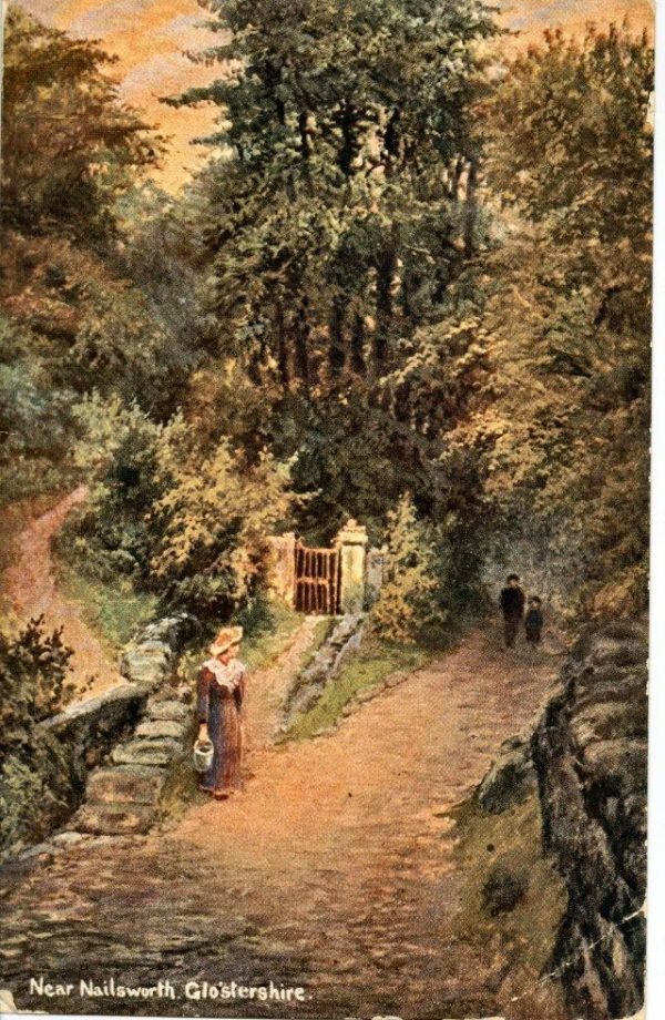
Two early photographs of the southern end of Box Wood, showing both the public footpath up to Box and also what was a gated, private entrance into the wood (now disused) leading from “Devil’s Elbow” (part of Pensile Road) through Box Wood and eventually to Box House.
Although the old private footpath is overgrown and will not be reinstated as a public entrance, the stone pillars of the gateway have been revealed and a new gate fitted, returning the gateway nearer to its former appearance.
Several old photographs and postcards of this location still remain, although often referring to it as being “Holcombe Corner”, “Holcombe Wood”, “Devil’s Elbow” or “Pensile Road” or simply, as in this rather romanticised picture (possibly taken from a painting) “Near Nailsworth”.

Devils Elbow, Pensile Road 1830
Box Wood, Pensile Road 1830

Devils Elbow 1840

Longford Lake 1840

The Devils Elbow 1840
Box Wood 2024 - Photograph by Michael McEllin

Box Wood 2024 - Photograph by Michael McEllin


Box Wood 2024 - Photograph by Michael McEllin